Saturday 25 June 2011

Fete de la Transhumance, Die, 25 June 2011

 Visit our website at: www.bowater.fr  to see a comprehensive selection of our work and a large range of photographs for sale as limited edition prints.

Die is a small place, very much la France profonde, concerned more with the quality of life than with fashions or fads.  Transhumance has been a feature of Alpine life since hunter gatherers domesticated and began to herd animals.  Alpine summers are fine and warm but the winters are harsh.  Domestic animals survive the winters in barns and byres in the valley and pastures at lower altitudes.

The thousands of hectares of high valley meadows and Alpine pastures that flower so gloriously in Spring are probably largely a product of transhumance.  Wild browsers in the mountains, decimated by the hunter gatherers, were replaced by flocks and herds driven onto the mountains at the beginning of Summer which eventually created the present agreeable mountain landscape.  Without the annual arrival of the of large flocks of sheep and cattle the mountain pastures would grow rank and turn to scrub.  The symbiotic relationship between the shepherds and herders and the landscape has worked very well and in regions such as this there is every reason to hope for continuity.  Apart from the maintenance of the landscape and the practicality of using abundant fresh pastures for grazing, it would be hard to find a less polluted and healthier environment in which to raise sheep and cattle.

The life of a shepherd, lonely, physically demanding and responsible, doesn't appeal to everyone.  Vast distances to walk, months living in simple huts and no great financial reward  -  and yet there are young shepherds and communities that support them.  The Fete de la Transhumance is a celebration of an old and honourable tradition.

The local brass band leads the parade early on Saturday morning to announce the arrival of 2 000 sheep and goats that pass through the town on their way to the Summer mountain pastures of the Vercors.


The flock crossing the viaduct into Die on a glorious June morning

. . . . and crowding into the Rue Camille Buffardel


Arriving at the Saturday morning market in the Place de la Republique


Passing through the market dominated by Die's atypical Cathedral.


Amongst the sheep are some splendid goats, full of character and sometimes a touch saturnine.

The flock passes through and a surprising number of enthusiasts follow them up towards the plateau.  The majority stays in Die to continue the celebrations.  Restaurants insensitively offer special lamb menus, bands and groups of musicians perform all over the town and on Saturday evening, to continue another honourable tradition, there is an abundance of choice of street theatre  -  dance, acrobats, jugglers, shows and displays.


Monday 13 June 2011

La Montagnette and the Vallon de Combau

 Visit our website at: www.bowater.fr  to see a comprehensive selection of our work and a large range of photographs for sale as limited edition prints.

After several days of much-needed rain, we took advantage of a break in the weather to return to the Vallon de Combau and the Montagnette on the Vercors Plateau.  Instead of taking the usual well-beaten path we opted for a different route in the hope of coming across something new.  

The Montagnette isn't particularly high, being just under 2 000m, part of an escarpment which runs approximately north-south along the edge of the Combau.  We clambered up the steep grassy slope towards the rocky summit.

The escarpment to the west of Vallon de Combau with the summit of the Montagnette extreme right

As we climbed towards the rocks, the sky clouded in and the light, being grey and flat and undramatic, was just not suitable for long distance landscapes.  So we have chosen some brighter views taken on a previous visit in October 2007 to supplement what we saw this time.

There were rewards for choosing the steeper route.  The decaying roots and trunk of a fallen pine, a natural sculpture suggesting Dali or Bosch, and containing almost any caricature you choose to imagine.


The slope is home to a colony of marmottes.  The marmottes were too quick for us but there are plenty of burrows and recent workings which is good news in an area that had lost most of its population of these endearing animals.  The other main occupants of this little forest are ants;  uncountable in their laboriously-constructed domes.


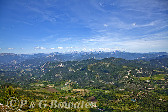
The view from the base of the cliffs is one of the finest in the area and we have chosen the shot below from our previous visit.

View from a limestone pavement at the base of the cliffs over the Vallon de Combau, Trieves, Devoluy and Champsaur with the peaks of the Parc National des Ecrins in the background.

In the view above, the sky is almost clear, as clear as we can get it.  This region is on a busy flight path and vapour trails are ever present though, fortunately, the aircraft are usually high enough to be hardly heard.  However, the vapour trails sometimes spread and cover the entire sky like a layer of low cloud.  But the air here is clear and the visibility often excellent.  We used to live in the Var with a distant view of the Mediterranean.  In the 1990s from our terrace we could often clearly see every detail all the way across the 40 Km between us and the sea.  By the time we left, a year ago, a clear view was a rare ocurrence, perhaps two or three times a year and the guilty pollution was all too plain to see.


Skirting round the low cliffs we walked up the slope to the summit and to the view of our favourite local mountain, Mont Aiguille.


Looking north from the summit of La Montagnette into the Isere, Mont Aiguille and Le Grand Veymont.


It seemed a pity to take the same route back as last time and instead we walked south along the edge of the escarpment and over the Sommet de Rangonnet.  Heading south, we walked into one of those magical corners that are such a delight to find.  Perhaps a niche with its own micro-climate, noticeably different vegetation, particularly pleasing Mountain Pines and dramatic geology on a small scale.  A stage set for Tolkien or a backdrop for a pre-Raphaelite painter.

A deep, probably very deep, cleft at the edge of the escarpment, with its own rock garden, and a view towards the Jocou and Mont Barral.

A fine Pinus Mugo, Mountain Pine, at the edge of the escarpment, shaped by the wind and the long, hard winter.

The map doesn't show a direct descent from the escarpment but an apparent break in the cliffs and a couple of tell-tale names, Pas du Loup and Pas des Brebis, suggests that there is a way down.  There is, but we failed to find a track of any sort and the going varied between steep and very steep.  It might have been easier to have retraced our steps but less enterprising.  After a long descent we followed a stream bed onto glorious meadows at the valley bottom;  meadows so carpeted with wild flowers that it was impossible to step between them.  On the way down the stream we stopped to shoot a couple of flowers.

Great Yellow Gentian (Gentiana Lutea) and a Dactylorhriza Orchid (at least that's what we think it is).  These handsome orchids, not at all uncommon, grow profusely all over the hills and valleys in this area.


The architectural flowering head of a Great Yellow Gentian just before coming into bloom.  Another common plant in the region though apparently threatened elsewhere. 

Like so many herbs and plants the Great Yellow Gentian possesses an abundance of medicinal and other properties.  It is the main ingredient of Angostura Bitters and of Suze  -  a liqueur from the Limousin. It also flavours an unusual Italian beer.  Extracts both from its bitter roots and fresh flowering parts have long been considered effective against various poisons and a general tonic for the digestive system.  The root is considered to be anthelmintic, anti-inflammatory, antiseptic, bitter tonic, cholagogue, emmenagogue, febrifuge and stomachic.

As the gathering of wild flowers is rightly strictly forbidden in France, we haven't tried the plant for any of its properties  -  though we have tried the liqueur.


Monday 6 June 2011

Joncheres and the Col de Volvent

 Visit our website at: www.bowater.fr  to see a comprehensive selection of our work and a large range of photographs for sale as limited edition prints.

About ten years ago we came to the Diois for the first time to hire a donkey from a local mountain guide, Patrice Weiss, who gave us a superb 12-day itinerary, walking and camping, with the donkey carrying most of our gear.  The donkey was a great companion but, as donkeys will, he almost succeeded in persuading us to carry him too.  We arrived in Joncheres via the magical Ravine de Trescoussous and spent the night in the village before tackling the Col de Volvent.  

The route to the top of the Col seemed particularly long and hard then, probably because our canny donkey decided to stop and get his breath back every 50m or so.  This time we drove to Joncheres.  The Col didn't seem quite as forbidding as before but was a little less appealing as the lower half has been cut for timber since our first visit and an access track has replaced the lovely old path that used to snake up through the woods.  But as the track entered the beech woods above the pine forest it was itself again.

It would be sentimental and illogical to complain about the thriving local forestry industry which goes a long way towards preserving the forests and creating new wooded areas of cleverly-managed and attractive plantations.  The managed forests are often at least as attractive to us and to wildlife as their more ramshackle neighbours.  And of course they create profit and employment.  Nevertheless, it's a pity that the age of timber extraction with heavy horses and overhead ropeways has passed.

Looking down on the perched village of Joncheres from the path to the Col de Volvent

The Col de Volvent, now used only by the occasional walker, was once a busy mule route from the Drome valley into the then more densely populated and economically important valley of the Roanne.  The track leads to St. Nazaire le Desert, once renowned for its fairs.  The path leads up to the Montagne de Praloubeau which rises to 1525 m and, to the north, the Montagne d'Aucelon, which form a natural barrier between the two valleys.

One of our reasons for returning to the Col de Volvent at the end of May was the hope of seeing the wild peonies in bloom.  This year we nearly missed them but found a few still flowering on shady slopes.  The peonies are far from common and we don't know where else to find them.


Having found the peonies and the path through the beech woods still intact, we settled down for lunch on the summit of the Gros Moure.  The weather was perfect apart from occasional gusts of wind and an alarming roaring, rattling sound from the other side of the rocky summit.  We presumed that this noise came from the wind through a tarpaulin or a corrugated iron shed put up by the shepherds who bring their flocks to the mountain pastures in summer.  Then we found the true cause of all this drama.  A whirlwind, far fiercer than the dust devils we've been used to seeing in towns, came over the summit and headed towards us, cutting off the grasses and small vegetation like a rampaging circular saw blade, about 2m in diameter.  It's hard to say how powerful it really was and probably it held no threats for us but it severely shook sizeable pines as it cut a swathe past us, roaring like a train.

Is paranoia winning?  After the whirlwind, we were woken from our reverie by huge shadows and looked up to see several Griffon Vultures (Vautour Fauve) circling above our heads.


Our walk took us southwards, down the escarpment towards the Col de la Motte with the magnificent views so typical of this area.


Views over Joncheres and Trieves to the Parc National des Ecrins.


After a steep descent we arrived at the Col de la Motte, once an important junction of mule tracks leading to and from the Drome to the Roanne and the Baronnies.  We then took the long and gentle track back down to Joncheres with the magnificent Glandasse as backdrop.